Since we have been doing more and more reservations while hangin’ in central Washington, we had a couple days to kill before our next reservation at the Pasco/Tri-Cities KOA. Jeanne found a popular boondocking spot called Rufus Landing right on the Columbia River in the massive dot-on-a-map town called Rufus. It is close to the intersection of Highway 84 & Highway 97, just west of the John Day Dam. It was literally a large dirt lot used by salmon fishermen with its very own pit toilet. The views in this area continued to be spectacular as we could see the John Day Dam, Mt. Hood, and even cruise ships heading up river.


The one touristy thing we did manage during our stay here was a short crossing of the river into Washington to see a replica of the English monument “Stonehenge”. This one was built to honor the (13) WWI veterans who died in battle that were residents of Klickitat County, WA. In addition, there is another memorial on site to honor the Klickitat County veterans who died in battle during all of our wars, up to and including Afghanistan & Iraq.


Pasco/Tri-Cities KOA was our next temporary home. This stop was more chores than fun. However, we did manage to give the bikes a workout, albeit on a trail(s) we had ridden back in 2020, the Sacagawea Heritage Trail/Columbia Park Trail combination. Some of the pictures may be similar to those taken the first time, oh well…


Wenatchee River County Park in Wenatchee was another return trip for us, we needed to kill a little more time before our next reservation. It is a small RV park right on the Wenatchee River and boy oh boy was there some water in that river! It looked nigh on close to flooded as the waters raged downriver appearing to have expanded beyond their normal boundaries. We took a pass on a revisit to the Apple Capital Recreational Loop Trail and again took care of some shopping chores before heading farther north (hey, Wenatchee is not so small as to not have a Walmart, what can I say?!)


Next up for a new home was the Entiat City Park, still on the banks of the Columbia River. This is a VERY nice campground! It seemed to be popular for locals to do some family camping, a lot of barbecues and suntan lotion whilst lazing at riverside. The campsites are very well maintained, surrounded by the greenest of green grass, and have nicely maintained raked sand tent sites besides the paved RV sites. There is a bit of an over-abundance of geese taking their walkabouts throughout the park, depositing the remnants of their last meals all over, keeping the camp hosts and city workers very busy cleaning the pavement/walkways and firing off some type of fireworks to shoo the geese along (kinda like the bird cannons the wineries sometimes use to keep the birds from eating the grapes). They also have a nice paved walking/biking path alongside the river through the entire park, then continues as gravel alongside the Entiat River which empties into the Columbia River at the park. At the confluence of the two rivers there is what locals refer to as “Numeral Mountain”. It seems since the 1920’s each graduating high school class scales/repels the cliff of that mountain and paints their graduating year on the rocks. Oh boy, rural entertainment at its finest!


About 30 miles up the Entiat River off of Entiat River Rd. we found Silver Falls Trailhead in U.S.F.S. territory. Always up for a look-see involving waterfalls, we headed out one fine early morning. Now Silver Falls is on, you guessed it, Silver Creek, which feeds into the Entiat River. The trail is pretty well maintained, USFS built quite a few sets of rock stairs throughout the whole trail and they have a lot of wood rail handrails scattered along the trail. The trail heads up the mountain alongside the creek, to a point where it forks left and right (it is a loop trail and this is where the two converge). I would suggest taking the right fork; this will afford you spectacular views quicker. The trail gains a lot of altitude pretty quickly but after the steep climb the trail makers took pity on us old folks and transitioned to several L-O-N-G, more gradual elevation gain switchbacks. It is very well worth the effort to get to “the top”, very beautiful scenery. I gotta backtrack a little. The body of water really is named Silver Creek. But it starts at the top of the mountain and flows/falls/cascades ALL the way downhill, in essence a continuous water fall down to the road! And a little more backtracking, I mentioned getting to “the top”. Well, the trail loops up to a point where it is pretty much “the top”, but you can see the creek is still slightly cascading from farther above your “at the top” viewpoint. But by this point at the top of the loop all of the dramatical waterfall action has been experienced. In all it was about a 2.3 mile round trip hike with a 700’ elevation gain and it took us about 80 minutes.


On our drive to Silver Falls we happened upon Box Canyon Viewpoint. OK, we’re in! It was a short dirt road to a parking area with a small trail down to the viewpoint. Box Canyon earned its name from early settlers who found it and described it as a straight sided box. The Entiat River created it by chewing through the granite over a whole lotta years. There was a nice viewing platform from where to observe the raging waters.


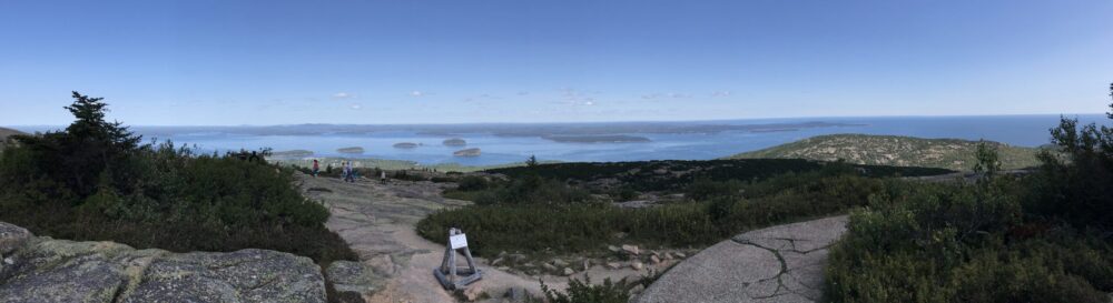
As if none of the previous day’s activities infirmed us enough, Jeanne found the Chelan Butte Trail and decided we would tackle at least part of that one. The trail starts in the city of Chelan and quickly gains elevation as you climb the massive mountain. We hiked (huffin’ & puffin’) a couple of miles to near Elephant Head, then doubled back. This trail affords vista views overlooking Lake Chelan, Chelan, Manson, and a great amount of the area around them. Once we got back to the Jeep, it was off to Chelan Butte Rd. and a run up to the lookout near the top. Part paved, part gravel, part 4-wheelin’, the views at the top covered the lake and a big swath of the Columbia River.


So now you are caught up with us. Stay tuned for our next destination. Until next post…


