Continuing our trek northward, we made a short stopover in Bend, OR and a return stop at the Elk’s Lodge. Since the Bend Elk’s Lodge RV sites are E only, it was a short stay. Jeanne had a gift certificate for REI so we ventured on down to the Old Mill District on the Deschutes River so she could spend her money. We did a little walkabout and checked out the scenery there also. Being in a fairly good sized city, we needed to get a new set of shoes for the Jeep, so a stop at Discount Tires was in order. A little tip for ye who don’t live in snow country…April/May is a bad time to want to get new car tires here at Discount Tire. Everyone and their mother who run snow tires on their family ride seem to go to Discount to get the snow tires swapped out with the good weather tires. We waited almost 4 hours for our tire job! Oh well, the joys of full-timing…


We managed to avoid the on again off again snow forecasts for the areas of Oregon we were in, but still got some good rain showers. We plugged on, our next stop being the Cascade Locks KOA at the Columbia River Gorge. A little bit of rain and cloudiness was not enough to discourage a little outdoorsiness. The area is permeated with hiking/biking trails, waterfalls, and overall great scenery along the river.


First order of business was a quick recon spin through the megalopolis known as Cascade Locks on the Oregon side of the Columbia River. The view across and down the river from the Bridge of the Gods was pretty cool. We also checked out the old historical locks in town, a set of locks from days of yore, no longer operating. In fact the lock doors aren’t there any more. But it gave us a straight shot down the river to the Bridge of the Gods.


The Wahclella Falls Trail was our choice for the first hike. It is a fairly easy 2+ mile round trip on a well maintained gravel trail with no real rock scrambling to speak of. The trail follows along Tanner Creek and actually accesses 2 separate water falls. The first one is Munra Falls. That was a neat “little” falls that is just a matter of feet off the wooden bridge along the trail. I say “little” with just a touch of sarcasm…Munra Falls is about 68’ tall and classified as a horsetail falls. A couple of more wooden bridges (well built, sturdy, well maintained, and solid) and we arrived at Wahclella Falls. It is a two-tiered waterfall, the upper falling about 50’ while the lower horsetail style fall is about 65’ and lands in a nice little pool area. We did hit this trail fairly early, right around 7:30 am, and found nobody else on the trail all the way to the end. But judging by the number of hikers we encountered on the return trip, it seems to be a fairly popular and busy trail as the day goes on.


We made one road trip from Cascade Locks, a little over an hour’s drive to the area of Goldendale, WA. We crossed the river and drove Hwy. 14 along the Columbia River and got some cool views from that side. At the area of Little White Salmon River flowing into Drano Lake which flows into Columbia River, on Drano Lake in an area locals call “the Toilet Bowl” there were multitudes of small fishing boats trolling in a circular pattern at a tiny end of the lake. Kinda like the “Keystone Kops” version of a fishing tournament.


Bonneville Lock and Dam just happened to be up the road from our homesite and Jeanne discovered they have a fancy visitors center. We graced them with our presence one morning just after they opened up. The dam is huge in the world of power generation and churns up the river in a pretty big way. There is a large fish ladder system on site as well, with a nice fish viewing window area at the lower level, below the water level of course (no duh!) Due to all the rain this season, the water was a bit, OK, a lot murky but still the fish are drawn by the back lighting at the windows so you can still get a glimpse of the power swimmers. The lock area was closed to the public, so we were unable to get a close peek at the massive lock system that elevates/lowers the big barges pushing cargo up and down the river.


After a couple of hours at the dam, it was time to break out the bicycles for a two-wheeled road trip. The Historic Columbia River Highway State Trail runs right through this area, so we hopped on at the Bridge of the Gods and headed west. It was a nice, paved bicycle path which had some pretty healthy grades as far as pedaling goes. The path travels alongside Hwy. 84 and the Columbia River. At one point we crossed Ruckel Creek and got treated not only to fantastic views of the creek cascading down the mountain, but Jeanne spotted what I think was an Osprey’s nest in a treetop nearby. We got to see incoming and departing Osprey’s, very cool. We rode the trail to the Cascade Salmon Hatchery at Eagle Creek. A quick self-tour of the holding tanks and it was back to base. I have to hand it to the infrastructure folks of the state of Oregon. This stretch of Hwy. 84 we were on had a ton of construction activity going on, and all of it an improvement project for the Highway State Trail. It’s nice to see governments spending our tax money responsibly on projects to benefit We The People.


The Eagle Creek Trail was in our gunsights, so it was off and running (no, hiking) one brisk early morn. The trail length approaches 14 miles, one way, to the end at Wahtum Lake. Since Woodrow Wilson (the family ankle biter) has given up on family hikes, he gets to stay and guard Rosie (the bus). Unfortunately, we get to suffer in that our hikes must be limited due to said ankle biter and his peanut-sized bladder. This hike we chose to go as far as Lower Punchbowl Falls, which made it a 5+ mile round trip. The whole trail boasts 8 “main” waterfalls, with numerous small falls along the way. Our trip we got to see Lower Punchbowl Falls, Metlako Falls, & Sorenson Falls. The trail was well maintained with not a lot of signage needed (or so I thought). There is some minor elevation changes, the steepest bit was going down the mountain to arrive at Lower Punchbowl. There are a couple of very narrow stretches along the cliffside high up on the mountain where the Forest Service people have installed thick cables for hand-holds, those sections might not be suitable for the squeamish. But hey, I’m squeamish and I made it, breakfast still in tact…Metlako Falls and Sorenson Falls are in the same area however they are not visible together (twists & turns in canyon and trail, you get the gist). Sorenson Falls is said to be about 100’ tall and is the first one you will spot. A touch further on the trail you will be given a view of Metlako Falls. It is about 82’ tall and both feed into the same deep pool in the creek. All along the trail we spotted a myriad of small falls and leaking mountainsides. We were able to hike all the way to Lower Punchbowl Falls and do some rock/tree scrambling around that small area of canyon. The sad thing about it, (as we learned after our return) is that supposedly about 100 yards upstream we could have encountered another waterfall called Punchbowl Falls. The entire canyon and its stability were compromised in the big wildfire of 2017. People used to be able to walk the creekside to see those falls, but now some major rock scrambling or wading/swimming the creek is required. This would be one of those times a little signage would have been helpful. Oh well…Water break and snacks done, it was off on the return trip. We encountered only a few fellow hikers on our trek out, but quickly realized we picked a good time to do the hike because on our way back we passed a whole bunch of hikers headed up the mountain. This trail requires a $5 use fee, or in our case the America The Beautiful pass. I think there is a point where back country use permits are also required, but as long as we have the Woodster, we will never be in danger of needing one of those.


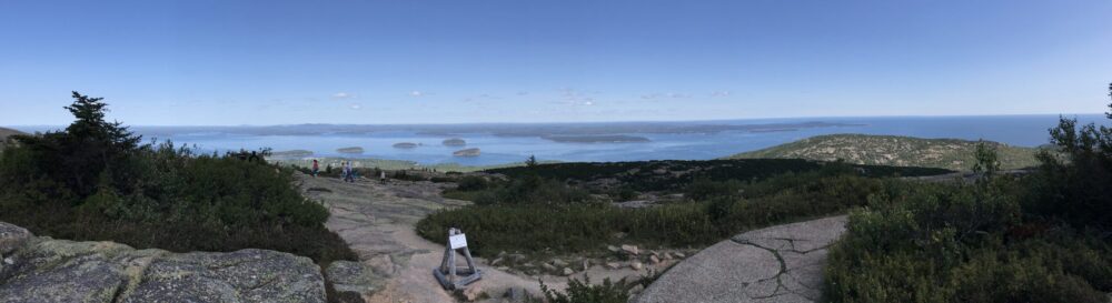
Our final excursion for this area we chose to hike Beacon Hill. It was across the river in Washington and described as the core of a volcano 848’ high. Over the years, the Columbia River has eroded the outer parts of said volcano, leaving only the core standing tall. The rock (as I call it) has some limited areas for mountain climbers to scale, but none were there for our entertainment. There is a trail to the top with an intricate system of switchbacks (55 to speak of, if my count was close) to help mediate the 800’+ elevation gain in the 1 mile distance up. The trail has a mix of sections made of concrete, rock/basalt, and some wooden boardwalks. It definitely will give you the willies if you have altitude issues, thankfully there is solid hand railing all the way. The trail and top give you sweeping vistas of this area of the Gorge and a long-distance overview of the Bonneville Dam. The hike took us a little over an hour to go out and back and again, we did this one early in the morning, no other hikers around. But once we started the downward trek, we met numerous upward bound hikers, one even had her dog along for the trip. I’ll let these pics speak for themselves, no captions…


Well, weather looking like it is improving, it’s time for a change of scenery. Stay tuned, until next post…
Nice to see you are back on the road, with the jacks up. We are headed out at the end of the month, Nashville and beyond. Meeting up with Phaeton friends in Nashville then headed up to the Ark, Creation Museum then swing South to Florida. We’ll be staying off the interstates and explore as we go along. If our New Jersey family do not come for the 4th of July, we will continue to explore till the middle of July. If you get to the East half to the country, keep in touch so we can meet up. Keep it between the lines.
Carol and Jim