Time to flee Kalifornia once again, we went jacks-up and headed east on our usual path of escape – the Tehachapi Pass on Hwy. 58. The temperatures have been cold to start the new year and we are in “weather watch” mode so as to not get hit with a lot of snow while traveling. I will never be a big fan of driving Rosie through snow and ice. We buckled down and pushed on into Primm, NV, and an overnight dry-camp stay at Whiskey Pete’s Casino. Then it was a short hop into our next stop, a return stay with the Boulder City Elk’s Lodge. The temperatures were absolutely frigid, but the mountains around Vegas had the very lightest dusting of snow. This stop was mostly for the purpose of getting chores done; Costco, Walmart, Trader Joe’s, Jeanne’s hair cut, a quick tire rotation at Discount Tire, and, OK, a small donation to the local economy (hey, Sin City, what else can I say?). We also made a return visit to Hoover Dam to check on the status of Lake Mead compared to our last visit.
Leaving the “scenic” state of Kalifornia, driving through the Lost Hills oil field near the armpit that is Bakersfield.Our overnight home at Whiskey Pete’s. Ahhh, solitude!Just a light dusting on the mountain tops around Vegas.Sin City!Lake MeadViews of Hoover Dam from the Pat Tillman Memorial Bridge.The water level is still down.Another angle over the top of the dam.
Moving on down the road, we conquered the battle of icy roads through the Flagstaff area and into an overnight stay at a defunct truck stop in Winslow, AZ. Up and at ‘em early, we motored our way to yet another return visit to the Enchanted Trails RV Park outside of Albuquerque, NM. A few days rest and on to our leased lot at The Ranch (SKP park) in Lakewood, NM.
Cruising I-40 through the Flagstaff area.Early morning ice can be treacherous!Our home at Enchanted TrailsEnchanted Trails still had the same display of antique cars/RVs in the middle of the park.RVing, retro style!Nostalgia on display inside the Enchanted Trails office. “Can we still dial in to the Jack Benny Show on this thing?”“Hello, Operator? Please get me Lakewood 5589.”“Can someone adjust the rabbit ears? We’re having trouble getting the Ed Sullivan Show.”Good morning, Albuquerque!
We got settled in for a bit of an extended stay, mainly to wait out the winter weather. I took the opportunity to do a few fixes on Rosie, at least the ones within my limited skillset. In all the cold weather our fresh water hose that is mounted on a motorized reel keeps freezing and snapping off small sections as I reel it in and out, so I had to replace the hose, not a difficult task. One of my more apprehensive endeavors was a clogged backflush spray head inside Rosie’s black tank (that would be sewer for you non-RVer types). A quick look on-line in the Tiffin RV Network (tiffinrvnetwork.com) and a huge leap of faith got me into the “belly of the beast” (Rosie’s guts) where I found the access to the backflush spray head to be very easy. I also tore into the (3) heat/ac units on the roof to clean the filters and hopefully discover the source of an interior water leak, the jury is still out on that one…
Here’s our welcoming committee back at The Ranch.It’s almost a daily display of Marlin Perkins’ Mutual of Omaha, Wild Kingdom!Black tank repairs, yewwwwwwwwww!Close-up of Rosie’s tanks Tearing into the AC/heat pumpsGood morning, Lakewood, NM
We utilized some of our time doing a little yard work around the casita. Being in the desert “yard work” consists mainly of playing with rocks. So we managed to kick our own butts, moving a total of (12) tons of rock that we had delivered by Southeast Redi-Mix from Carlsbad. The long dormant muscles that we both gave a rude wake-up call to are still screaming at us!
The first load…One load down…Quittin’ time, time for a Mule!
Rosie developed another coolant leak from the low coolant sensor, necessitating a road trip to the nearest Freightliner shop in Odessa, TX. A couple of nights camped out in their lot and, since we were there, what the heck, it was north to Lubbock for more big box shopping. We returned to the Lubbock Elk’s Lodge for a few days stay. Unfortunately for us, those few days included a pretty good dump of SNOW! It created some fun time (NOT) on our day of departure, it took me almost 3 hours to thaw the icicles and clear the slide toppers just so we could fold up the slides. Success attained, it was jacks up and back to The Ranch.
Our home at Odessa FreightlinerNow THIS is resort living for the full-time RVer!Back at Lubbock Elk’s Lodge, windy as is common…It’s only snowing a little bit…Oops!OK, OK, OK, turn the snow machine off already!Frosty the Snowman came to visit!
Clearer weather at The Ranch, we completed the finishing touches to our landscape project. Our backs and shoulders were happy to see the final placement of rocks!
Get me out of Texas!Back at The Ranch, yard complete!Yee-haw!
We have been meaning to pay a visit to nearby Sitting Bull Falls, just haven’t had the time/opportunity to venture out. With the yard done for now, we caught a nice weather day and headed out to the falls. New Mexico did a really nice job on the infrastructure/facility at this tiny little podunk-nowhere natural attraction. It is REALLY way out in the middle of nowhere, 32 miles off the “main” highway near the megalopolis of the “town” of Queen (basically, a cafe, a tin barn fire department, and a whole lot of nothing). The hike to the bottom of the falls was short (a couple hundred yards…maybe) and mostly concrete walkway. The water pools at the base of the falls was crystal clear beautiful, reminiscent of the clear waters in Montana. We also discovered the existence of a trail straight up the mountain which takes one to the spring headwaters for the falls. We were not prepared for a more strenuous hike at that time, but hey, now we have another activity to look forward to.
So this catches you up for now. I’ll leave you with a photo that represents the stressful lives of full-time RVers. Until next post…
The area of Kanab, UT was our next temporary home. We found Country Rose RV Park in Fredonia for a couple of night’s respite. There is a popular trail in the area to access Peek-A-Boo slot canyon (AKA: Red Canyon Slot). We fully intended to conquer said hike…until we stopped by the visitor’s center in Kanab. There we were regaled with horror stories about the 4WD section of said trail winding through nothing but soft, pillowy, thick sand and the $1,000 cost of getting towed out after getting stuck, even in 4WD. Time for Plan B. Jeanne found the Best Friend’s Animal Sanctuary just north of town. It was a large stretch of land used as a sanctuary for various animals, as well as a large pet cemetery, and the road through provided some nice scenery.
Onward and upward, we were off to a few days stay at the St. George (UT) Elk’s Lodge. They have a nice lodge parking area with 13 power pedestals (30/50A) and the lot overlooks a 9-hole municipal golf course. The course was a beautiful deep green which was an awesome contrast to the bright red rock formations surrounding the lodge.
Home, at the St. George Elk’s LodgeLots of red rocks…Tribute to Veterans at the Elk’s LodgeYeah, it got a little busy.
We found Pioneer Park nearby and thought we might avail ourselves of some of that hiking. It was a bit disappointing, there really were no trails of any significant length, but the scenery was great. There is a “slot” canyon of sorts called St. George Narrows which we got up close with. I say “slot” a bit facetiously, it would only function as a through and through slot canyon if you have a waist line measurement of 2”. Jeanne and I had just been extolling the virtues of the area and its lack of homeless freak bums when by golly I stumbled upon a thrashed campsite inside a small windcave type crevice in the rocks. Such a pitiful eyesore…
Good-bye once again to St. George, we were pushing on towards the left coast. We discovered there is actually an Elk’s Lodge in Ely, NV so that seemed a good stop off for a couple of days. They share a gravel parking lot with the Hotel Nevada Casino, so in we went, dry camping only. It promptly came to our attention that we were coincidentally in time for The Great American Eclipse on 10/14/2023. Oh joy.
Our home at the Elk’s Lodge.Downtown shot of Ely, NVAll kinds of goobers come out for these eclipse thingies…Trying to fry my i-Phone camera, not a great shot but you can see the “ghost” image of the full eclipse
Once we “got eclipsed”, it was “On The Road Again” to another Country Rose RV Park, this one in Fernley, NV, for a couple of days getting shopping chores done. Then we opted to head over the mountains through Susanville and on to Redding for a stint helping Jeanne’s brother Dave while he underwent some minor eye surgery. We split our time between the Redding Elk’s Lodge and Win-River Casino. Deep sadness struck again. Woodrow Wilson has not been doing well for the past couple of years, firmly in the grasp of what we believe was Cushing’s Disease. We made the difficult decision to end Woody’s suffering at the Cottonwood Small Animal Clinic since he had been a patient of theirs several times over the years. Those people are top quality there, very respectful and compassionate. Vaya con dios, little buddy!
With Woody now in a way-better place, we chose to honor his memory with a lengthy day of hiking. No more limiting our away time to a couple of hours, we drove up to Mt. Lassen National Park. We picked out Brokeoff Mountain Trail to “break the ice” so to speak. Oh my, with a long period of only short hikes, this was tough! The trail is listed as “strenuous”. It was. Very. Strenuous. It is ALL uphill, some sections pretty steep, 3 3/4 miles to the top, with a 2,600’ elevation gain. It got a little windy and cold near the top as well. I say “near the top” because we ended up pulling up about a half mile short, out of gas and out of will. The views were still spectacular. After the knee-cracking, quad-burning, calf-burning return downhill, we headed for a little more torture. The trail to Kings Creek Falls, albeit a little less elevationally challenged, was about a 2 mile round trip. The poor ol’ legs barely held out but we made it to the falls. The downfall to enjoying Mt. Lassen Nat’l Park is it was severely scarred by the 2021 Dixie Fire, so a lot of the hiking is through burned out forest areas.
Our last pit stop in Texas was an overnighter return trip to the Wild West RV Park in lovely Van Horn. The last time we stayed there we got hit with about 3” of snow, but this time we survived without extreme weather. Continuing, apprehensively, it was westward ho’ on I-10 through the belly of the beast, aka: El Paso. We were pleasantly surprised, despite all the current issues at the border, we made it through without a hitch. We took it all the way to Deming, NM for another overnighter return stay at the Escapee’s RV Club, Dream Catcher RV Park. Then it was on to a few days at the Apache Junction Elk’s Lodge in Apache Junction, AZ. They have a couple of areas around the lodge for RV’s, one containing designated camp sites, the other just an open field area, both strictly dry camping, with a minimal fee of $10/night for the designated sites.
We hit a couple of the Indian casinos in the area, but the highlight of that stop was a hike we took into the Superstition Mountains. Jeanne found the Siphon Draw trail in the Lost Dutchman State Park and we hit it on a crisp but clear morning. The trail is about 5 miles, round trip, with a 1,000’ elevation gain (according to the ranger) in the last half mile to the top. I would classify the trail as moderate; there is some minor rock scrambling, some surface areas similar to slick rock surfaces, and definitely a good elevation gain at the peak. The trail was busy, almost “crowded”, and well defined with little signage. The views were very nice as evidenced in the following pix.
Moving on, next stop was, again, a return stay at the Escapee’s RV Club, North Ranch RV Park in Congress, AZ. We made good use of the stop to get thawed out (hook-ups, Yippee!), laundry chores (hook-ups, Yippee!), and a general respite from all the one-night stay traveling (hook-ups, Yippee!). While at North Ranch, one of the locals mentioned he knew of a few crested saguaro cacti along the dirt road to Stanton just a few miles from Congress. Always on the lookout to find those anomalies of nature, we took a drive out to Stanton. I don’t know about “several”, but we found (1) crestie about midway on the road to Stanton. The area of Stanton is definitely nothing to write home about, no real vestiges of civilization other than a “rustic” looking RV park and several scattered homes/trailers. The (6) mile dirt road to get to Stanton is a little rough as far as several “washboard” stretches, I personally would not want to drive Rosie down it.
Some of the views on the “road” to StantonHere is the lone cristate (crested) saguaro we found enroute to StantonLooks like an avian type being has taken up residence inside the crestyThis one was across the highway from the Congress post office
Being sufficiently thawed out, we backtracked to Sun City for a few days of dry camping at the Sun City Elk’s Lodge. The lodge has a few RV parking spaces out in the back of their paved parking lot for which they garner a $10/night fee for the no-hookup enjoyment. The extra added benefit for our stay here was frequent fighter jet fly-overs, day AND night, courtesy of our friendly neighborhood military installation, Luke AFB. We found out quickly that this is one very busy Elk’s Lodge, evidenced by the packed parking lot every day we were there and the near standing room only condition of the lounge.
Our home at Sun City Elk’s LodgeLodge parking, sometimes at a premiumInside the lounge at the Elk’s Lodge, on a typical day…Our view from the parking lot, you’d think we were in Florida…Fly-bys, courtesy of Luke AFB
In between shopping chores at the plethora of opportunities we had while here in the big city we found the New River Trail which winds its way through the heart of the beast alongside a “river” that was a typical desert river…dry as a bone. Nevertheless, out came the bicycles for about a 20 mile excursion along the well maintained, paved, well used trail. Not one of the more scenic trails we have been on, I have to say…
Laughlin, NV was next on our westward itinerary. We did a couple of nights at the KOA just outside of the “downtown” area, across the street from the Avi Casino/Resort. Laughlin does not offer much other than several large casinos, or you can cross the river back into Bullhead City, AZ for any shopping needs (they DO have a Walmart, for Pete’s sake!)
Home at the Laughlin/Avi KOA
From Laughlin it was on to Pahrump, NV and another return stay at the Pair-a-Dice Escapee RV Park. We wanted to get some business done (aka: stay put to receive some Amazon deliveries, send for our mail, etc.), so we decided to stay for at least a couple or three weeks. Pahrump is about 45 minutes from Vegas, so we also wanted the access to civilization (aka: Costco & Trader Joe’s).
Check out the backdrop for our stay in Pahrump. Brrrr!Our home at Pair-a-DiceSome of the neighbor’s yard art. Or is it?
Red Rock Canyon National Conservation area sits just outside on the west side of Las Vegas. We took Woodrow Wilson on a sightseeing drive through the canyon, along the approximate 10 miles long scenic drive. It was mildly scenic at best, comparatively speaking, since we happen to be here amidst REAL scenery like Death Valley to the west and Grand Canyon to the east (just to name a couple), those are pretty hard to beat. But, Red Rock Canyon is still a very busy park, numerous hiking and horse trails everywhere.
As is my custom, we got treated to the usual weather events in Pahrump. After checking the weather forecast (by the “expert”, well educated meteorologists at “WeatherBug”, who, as it so happens all must have failed the courses on “Accuracy 101”), seeing no rain in the future, I gave Rosie a bath and got her all shined up. That back-breaking endeavor got me a whole day of enjoying the shine before, not only did we get rained on, but we earned the simultaneous added bonus of extreme winds with a massive dust storm (dust storm during a rain storm?) I can’t help but feel like Charlie Brown after Lucy pulled the football…
Rain/dust storms? Are you kidding me?!?Driving down the main drag during our rain/dust storm
After fighting the goofy weather swings and having water hoses freeze (again, the genius meteorologists did not forecast sub-freezing temps), we were happy to raise jacks and hit the road from Pahrump. Our destination? Stay tuned, until next post…
The Elk’s Lodge in Grand Junction was our next landing spot. The lodge itself is an old historical type building with a very cool lodge meeting room. They had electrical hookups in the parking lot for a few RV’s, but otherwise it was a dry RV spot.
Welcome to the Colorado Springs Elk’s LodgeOur home at the Elk’s LodgeA cool meeting room at the Lodge.
We found the Grand Mesa National Scenic Byway just outside of town, so the roadtrip was on. We got some scenic views of the valley floor as well as a curious Bambi who stared us down while I took pictures. The loop was about 63 miles in length.
God’s countryCool rock formationsViews from the topBambi watching usMore views from the topI think this lake was named Island Lake. I wonder why…
A walk down Main St. (just around the corner from the Elk’s Lodge) showed off some of the local art work scattered along the street. We also noted this area of Grand Junction, besides being near the police station, was home to numerous homeless folks. Not a great selling point for any possibility of landing here when we retire the full-time life.
A couple of days and it was onward and upward, more like eastbound and down, to the town of Glenwood Springs and our stay at Glenwood Canyon Resort. This was a very nice RV resort right on the Colorado River in a tight little canyon with great mountain views and a whitewater rafting business run right out the back of the resort.
Our home at Glenwood Canyon ResortRafters behind the resortLooking over some of the cabinsThis is a view from some of the tent sites at the resort. Willy Wonka’s chocolate river is actually the Colorado River after heavy rains.Some of the cabins are right on the riverDefiance Rafting Co.The clubhouse on the riverThe bicycle path along the riverMore of the cabins
Jeanne found the Hanging Lake Trail in her list of things to do. The trail requires a $12 permit per person to hike to the lake and they regulate how many hikers are on the trail at any time, a preservation effort by local government. We hit the trail bright and early one day with very little hiker congestion. The trail, a little over a mile to the lake, gains a lung-busting 1,100 feet in elevation, going straight up the mountain. Once we got to the top, we found the beautiful lake and a side trail further up the mountain to another waterfall with a feature called the Spouting Rock. Spouting Rock was directly below the waterfall and is a large volume of water spurting out of the rock creating a secondary waterfall. We relaxed in the serenity, had some snacks and recharged our batteries (so to speak), then enjoyed the all-down-hill return hike to the Jeep.
On another day we fired up the bicycles and headed out on the bike trail that runs next to the RV park. It follows the river east to the Hanging Lake Trail area and west into Glenwood Springs. Again, we enjoyed some scenic views in both directions, then I had a little “run-in” with a local chain link fence. It bit me pretty good and unbeknownst to me I lost my cell phone in the confrontation. But the good people of Colorado, at least one good samaritan, saved me by turning it in to the front desk of the Spa of the Rockies, a large mineral springs resort for which the aforementioned chain link fence was providing security.
We found another short adventure in downtown Glenwood Springs, the trail to Doc Holliday’s grave. It was a very short walk up the hill to the old Linwood Cemetery and the adjacent Potter’s Field (a cemetery for indigent and unknown folks commonly known as a pauper’s graveyard.) Besides Doc Holliday’s “gravesite”, Kid Curry was also buried, in the Potter’s Field. Kid Curry was associated with Butch Cassidy and Sundance Kid & their Wild Bunch. And I say Doc Holliday’s “gravesite” because they are not all that sure where, exactly, he IS buried within the cemetery.
A few days in Glenwood Springs and it was off we went. Our next stop…(?)
Just before we made our exit from Prescott, AZ, Jeanne & I ventured back out for a hike on the Constellation Trails. On our previous hike of the trails we kept to the interior trails. This time we chose to do the outer loop which is a little more than 2 miles and includes the Ranch Road Shortcut, the Rock Wall Trail, the Lost Wall Trail, and the North 40 Trail. The hike was moderate, only about a 200’ elevation change, minimal rock scrambling (you can add all the scrambling you want, in and amongst all the granite rock piles and formations), and very scenic but the only critters we encountered were the lizards.
Once we went jacks-up, it was “westward ho!” We did a couple of one-nighters at the Needles Elk’s Lodge and the Pilot truck stop in Tehachapi, then a two-nighter at the Merced Elk’s Lodge, and hit our destination of the Petaluma Elk’s Lodge as our base for doing our medical chores. Several days later, those chores done, we snagged Max for his summer adventure. We had him for a couple of days in Petaluma, then raced on out of Kalifornia, eastbound & down, to the Boomtown KOA on the NV-CA border. We did a 3-night stay for the weekend, Max & I making good use of the pool & hot tub. That hot tub turned out to be a real perk at the end of one particular day. Jeanne found a waterfall hike for Max to take us on, after a pre-requisite visit to the Cabela’s store for some hiking gear, of course. The Hunter Creek Trail leads to Hunter Creek Falls and is a very popular hiking trail for the locals. It turned out to be a 7 mile, round trip hike (out and back, not circular), with a 1,300’ elevation gain, no rock scrambling for the most part, with just a couple of short sections of very loose shale. To get to the best viewing area you must navigate some downed trees/limbs in the creek, and that could be problematic for those with balance issues or limited tread shoes. But if all else fails, the creek is only about knee deep at the deepest, there are plenty of spots where it looks ankle high. The views along the hike, as well as the waterfall, made it well worth the effort. While at the KOA we just HAD to walk on over to the Boomtown Casino where they have an arcade room for the kids. Max got his fill of arcade fun and we topped it off with his favorite meal (“cheeseburger, plain”) at the Mel’s diner.
This mama was our neighbor at the Merced Elk’s LodgeMax at Shollenberger Park, Petaluma, CAYeah, low tide STINKS!The adventure beginsYay! We made it to the Boomtown KOA!Max heading over to the casino for a little arcade time…Max & Oma prepare for the Hunter Creek Trail hike…Off we go…Max was always on the lookout for caves…Rest break with Oma!Max liked the waterfallGood thing max brought his good hiking shoes for thisThere were lots of mini waterfalls along the creek.Are we there yet!?
Boomtown in our rear-view, it was southbound toward Pahrump, NV. We wanted to show Max the “boondocking life”, so we did a one-nighter along Walker Lake at the Sportsman’s Beach Campground. We have stayed here a couple of times before and it is a popular stop over for many in the full-time RV lifestyle but we have never found it crowded (OK, usually there is nobody anywhere in our line of sight). We spent the day walking down to the water’s edge, chasing lizards. And too bad for Max that he does not wake up for Woody’s 2:30 a.m. toilet run, at that time I got a pretty spectacular night sky view including the Milky Way! After all, we were in an area of Dark Sky Parks (getting awful close to Death Valley).
Our campsite guard lizard at Walker LakeNow that is what I call a tough view…The water was like a mirror…
Moving along it was off to a couple nights stay at the Pair-a-Dice SKP RV park in the happening hamlet of Pahrump, NV. This was basically a rest stop along our route, with time enough to get laundry chores done and enjoy the triple digit heat. That is a wrap for now, consider yourself up-to-date. Until next post…
Yeah, it’s been a while, but not a lot to catch up to. A lot of family stuff keeping us on the left coast, but we did manage to sneak over to southern Nevada for some alone time. First stop was bee-you-tee-full Pahrump, Nevada where we spent a couple weeks hangin’ at the Pair-A-Dice SKP park. With the insane China-virus-hysteria still in full force, going places and trying to live life normally is still nigh on impossible. The really nice thing about Pahrump is it is surrounded by open desert, with scads of areas to head out to in the Jeep and cap a few rounds off to relieve some of the daily pressures (OK, so the only limit on the number of rounds I capped was the severe pain-in-the-ass shortage of ammunition available in any of the gun & shooting supply stores).
Home, at Pair-A-Dice
It’s terrible having to see skies like this…
Prepping for the range
Do I even remember how to do this? “Load with 6 and holster!” “Load with 6 and holster!” (Did I just date myself there? Phrases from the wheel gun days?)
Heading, yet again back into “unfriendly territory” that is, Kalifornia, we wanted to do a few days of boondocking on the west side of Death Valley, a place known as the Panamint Valley dispersed camping area. This would turn out to be more of an adventure than we bargained for. Taking Hwy. 190 west through Death Valley, between Stovepipe Wells & Panamint Springs, we encountered a “glitch”. Now having been full-timing on the road for over 8 years, ocean to ocean and passing through all of the lower 48, I have traversed some of the steepest grades this country has to offer. But on this particular trip, I have found one of the worst. The above mentioned section of Hwy. 190 happens to contain a 9 mile stretch of 9% downhill grade. Thus far I have been able to manage all grades utilizing my lower gears coupled with my engine brake. Any brake use has been infrequent pumping just to take the edge off my RPM’s. But 6 miles into this downhill we got nailed with “that odor”. I immediately found a skinny piece of shoulder to pull off and stop. As I opened the door, the tell-tale “wisps” of smoke were emanating from my front wheels. Ouch. So there we sat, staring off at the flat valley floor 3 miles ahead. After a 30 minute “brake” break, I fired ol’ Rosie up and continued downhill. Not wishing to even touch my brake pedal, I made it down the remaining 3 miles using only first & second gears with the engine brake and absolutely no brake pedal use. Whheeeeeewwwwww! We made it to the dispersed camping area just west of the road to Ballarat and gleefully set up for a big “brake” break, 3 night’s worth, to be exact.
How’s this for self-quarantine?
We did have daily visitors from nearby China Lake NWS
And here’s the guilty party who ruined our International Dark Sky experience all 3 nights…
Being this close to the ghost town of Ballarat, we just HAD to see it. It was a mere few miles drive down the dirt road (don’t worry, all you “pavement Princesses” out there, no high clearance or 4×4 necessary) to get to the “center of town”. This was about as disappointing as a “ghost town” could be. There were a couple of mud walls here and there, old metal parts and pieces scattered about, and one whole building with a sign designating it the “Ballarat Jail-Morgue 1898”. I have my suspicions as to the authenticity of the sign.
Just walls left on all but one building in “town”
The Ballarat Jail-Morgue
Fine desert accomodations…
All the interior walls suffered graffiti over the years.
A supposed gravesite next to the Jail-Morgue. I have my suspicions as to the authenticity…
Seeing we had been to Death Valley on a few prior trips, there was not much to try and see. But we were close to the Windrose Charcoal Kilns so we took the slow drive up into the hills. The kilns were used by the early miners to create the fuels (charcoal, I presume) used for smelting. We found them to be pretty well preserved.
A charcoal kiln
10 of them, lined up all nice and neat…
Inside the kiln
A view down into the valley from the kilns
We even got to see some wild ass…2 of them
The really big downer about this time around in Death Valley, it happened to be nearly full moons all 3 nights. If you are not aware of it, Death Valley is an international Dark Sky Park. Needless to say, skies aren’t much dark if there is a big ol’ lit up cheese ball right in the middle of them. We missed out, big time.
OK, so that kinda catches us up for now. Until next post…
Jeanne found us a spot to do a little boondocking just outside the Valley of Fire S.P. near Vegas, at lat/long 36.444454 – 114.675583. It was on a nice & wide/level gravel road on BLM land with ample numbers of “sites” for rigs of all sizes. In fact, I was able to make a U-turn on the dirt road with our 40’ MH (with toad). We had all of (4) “neighbors” that were in visual sight but scattered pretty well. After set-up, we ventured out to let Jeanne do a little Jeepin’ in the area while exploring our new back yard. The weather here was cool but clear, 50’s-60’s for highs, and the lovely cholla’s were just starting to “glow” (you know, where the little prickly pods are starting to morph into the appearance of cute, but lethal, fluffy cotton balls…ouch!). A negative here was that our closest neighbor (100 +/- yards away) ran their generator all night long. Some folks just seem to think boondocking negates RV-etiquette of maintaining some semblance of “quiet time”. Thankfully, they left the next day. I discovered an additional RV-etiquette violation by this former neighbor – they had (3) very large K-9’s which were allowed to fertilize the edge of the desert (in a very prolific manner I might add). I don’t care if you do need a backhoe, CLEAN UP AFTER YOUR %$#&*@! DOG!!!!!!
Our home near Valley of Fire S.P. Neighbors were a bit of a distance away.Barrel cacti were going crazy as well as the chollas.Looking down on us from the hills. Nice place to boondock I have to say…OK, OK, so they weren’t much challenge as Jeep trails go…Jeepin’ through the desert.Night views in the desert.
We got up the next morning, gave Woodrow Wilson a walkabout in the desert, left him to guard Rosie the Bus, then we ventured over the mountain into Valley of Fire S.P. When we boondocked out at Government Wash along Lake Mead several years ago, we managed to sight-see most of the area except for Valley of Fire S.P. This day we drove the whole park, west entrance to east entrance, then Visitor’s Center up White Domes Rd. to the White Domes Trail. Because of time (Woody back at the bus), we were not able to hit all the features of the park, but did get a couple of hikes in (White Domes & Fire Wave), then got to see Arch Rock, Atlatl Rock, Beehives, Seven Sisters, the Cabins at Lone Rock, the Clark Memorial, Elephant Rock, and a drive around the Scenic Loop Rd. I do have to say despite this Park being a very scenic experience, as far as the level on my “spectacular meter”, it is not as high as was the “Bowl of Fire” that we experienced during our first stay in the area at Government Wash. It is still worth a visit. And for all you tent campers and smaller RV types, there are a couple of campgrounds with at least some sites for smaller RV’s with W/E hookups, those campgrounds/sites wedged in between some of the beautiful red rock formations.
Arch Rock, Valley of Fire S.P.Some of the “scenic” along Scenic Loop Rd.We couldn’t resist. This is our little Cocker Spaniel Madison, passed away in 2015, now memorialized in rock formation.Atlatl Rock, site of some petroglyphs.Petroglyphs from long ago, on Atlatl Rock.The White Domes Trail On the White Domes Trail, this structure still stands, as described in the next pic.Movie sets in the Valley of Fire. Close up view of the movie set.The White Domes Trail winds through a slot canyon.Views along the White Domes Trail.Scenery at the Fire Wave.Sometimes you just get plum tuckered out! What a view!More from Fire Wave.And one more Fire Wave sight.Elephant Rock.A little history about the Clark Memorial.The Sergeant’s memorial.More than likely Sgt. Clark’s last view on Earth.Another of our “ugly” night scenes…
Our next stop was a scheduled service for the MH & the generator at the No. Las Vegas Cummins shop. We were very satisfied with their customer service and work that they had done for us when we had the malfunction with the Bakersfield Cummins shop last year, so we decided to get our yearly service done here now. And they have several sites for RV’s out front, with E hookups. After a frustrating delay waiting all day for an air filter to be delivered, we finally were able to hit the road.
Waiting on an air filter at the No. Las Vegas Cummins
We were still in the mood for more boondocking and decided on the area around the big megalopolis of Congress, AZ. We needed some hookups to prep tanks and do laundry, so we returned to the North Ranch SKP park to do just that. We also did some recon scouting up on Vulture Mine Rd., an area we had previously boondocked at. There was also a boondocking area out next to the old Congress Cemetery we checked out. That one was a little bit rough as far as the dirt roads went. After all was said and done, we decided against a repeat boondock in this area. But before we lifted jacks, we spent a day on an 8-mile hike at the Granite Mountain Hotshots State Park. The park is a memorial tribute to the local Hotshots crew who lost 19 of 20 members in what was called the Yarnell Hill Fire back in 2013. The hike traverses through the Granite Mountains with a 1,200’ elevation gain and up to 8% grades, with sweeping views of Congress, Wickenburg, and Yarnell. Along the trail they placed memorial plaques for each of the Hotshots that perished during the fire. The hike was moderate+, I wouldn’t call it strenuous but it had this 60 year old and his lovely wife “a-huffin’-and-a-puffin’”! The plus was that it was mostly uphill from the start, then once we got to the observation platform it was only about 3/4 mile down to the valley floor and the fatality site. That meant the return hike was downhill from the platform…The fatality site has a memorial built around it, a very somber, melancholic atmosphere. I can only imagine the level of grief for the families of the firefighters, now knowing and seeing just how near the crew had been to their designated “safe zone”. That would be the ranch that appeared less than 400 yards from the fatality site. The park ranger we spoke with said “the ranch” had that designation due to the wide clearing of brush from the structures, as well as the stucco construction with metal & tile roofs. Such a sad note to end our stay in Congress, AZ…
Our home at North Ranch SKP ParkThe sign welcoming visitors to Granite Mountain Hotshots Memorial S.P.A little background/history. Overall trail map.Jeanne starting the uphill trekIndividual memorial plaques along the trail.Another of the 19 memorial plaques. We had a hiking buddy with us…I swear I could hear him asking, “Where’s Eric G.?”Views from the trail The observation platform above the fatality site.A little more history……and yet some more history. Looking down at the valley floor, fatality site, and safe zone.The tribute wall at the observation platform.Close up of the fatality site. Close up of the ranch designated the safe zone.A remnant of the devastationA ground level view of the gabions surrounding the fatality site.One of the gabions up close. The cross memorials for the fallen.No need for caption.I’m wondering to myself, why do they call this Granite Mountain?!?
So now we were eastbound and down. Our “goal”, if you want to call it that, was to get back to the great state of Texas where I need to renew my driver’s license (in-person due to the Class B endorsement) and get our Jeep & bus safety inspected (a requirement for Texas vehicle registrations that we have been able to waive in the years we were not present in state). We hooked up to I-10 outside of Phoenix and settled in for our stop-n-go eastward journey. In Tucson we found the Desert Diamond Casino & Hotel that welcomes RVers to stay in their back parking lot (free, dry camping). I never asked the security folks I talked to about stay limits, but the casino only asks RVers to check in with them if they will be staying longer than one week. We used our time at the casino to get some shopping done, then relieved the casino of a few bucks, only to feed it back to them a little later. We also checked out one of the many local microbreweries, the Sentinel Peak Brewing Co. It was created by a trio of firefighters “moonlighting” as beer aficionados. The beers I tasted were OK, just did not give me the “WOW” factor. Jeanne found a little Mexican restaurant touted as the nation’s longest running family-owned & operated Mexican restaurant (since 1922) called El Charro Cafe. We hit them for lunch and had an excellent meal, definitely one of the best Mexican restaurants I have eaten at.
Our home at Desert Diamond CasinoSentinel Brewing Co. Some of Sentinel’s offerings.I’m hungry!
From Tucson we continued East for a return stop at the Dream Catcher SKP park in lovely Deming, NM. With not a lot for us to see that we already haven’t, we got chores and shopping caught up, got to send for supplies at amazon.com , and even squeezed in a road trip to beautiful downtown Columbus, NM, which is a bordertown neighbor to Palomas, MX. You can all pass on making Columbus, NM your top vacation destination.
Our home at Dream Catcher.City Hall for Columbus, NM.A glance down the desolate highway to Mexico.The one “museum” in Columbus. The front of the museum.The museum contains all kinds of “stuff”, from Pancho Villa days to WWII.Stuff……and more stuff.I saw this and immediately thought of my friend and fellow retiree Terry Kelly.The motel for Columbus, NM.One of the few dining establishments here in Columbus.A little history of Columbus.
The boondocking lifestyle was still calling to us. Jeanne found Sierra Vista Campground (BLM) just outside of Dripping Springs Natural Area at the base of Organ Mountains-Desert Peaks Nat’l Monument, in Las Cruces, NM. We found it to be a very small (limited spaces) improved area in the desert just 7 miles from town. There are no services/amenities, it is free, and carries a 14-day stay limit. We lucked into a site that could accomodate a 40’ beast. It is fairly popular by the way it stayed filled up while we spent 8 days there. This area had some hiking trails running off into the desert, as well as some easy Jeep trails where Jeanne got to test her skills at avoiding brush scratch on the Jeep.
Our home at Sierra Vista CampgroundAnother shot of the “campground”Nice views from our site.Neighbors weren’t THAT close.Jeanne, the 4-wheel drive queen.“Yeah, I’m bad!”Mr. Roadrunner, hiding from Wile E. Coyote…
We ventured up to the Dripping Springs Nature Area (sans Woodrow Wilson), where Jeanne & I took about a 7 mile walkabout to check out the springs, Van Patten Mountain Camp (ruins from days gone by), Boyd’s Sanitorium (also ruins from the past), Fillmore Falls (alas, dry as a bone at this point in time), and La Cueva.
Just a friendly warning…I’m already thirsty!On the Dripping Springs Trail Views from the trail.History lesson.Looking at the chicken coop and mercantile from days of old.The livery.The chicken coopJeanne taking in the scenery.History of Van Patten’s Mountain CampWhat’s left of the camp. Ruins……ruins……more ruins……and still MORE ruins.A blurb about the springs.The Dripping Springs with the reservoir built above it.Close up of the Dripping Springs.History of the sanatorium.Dr. Boyd’s SanatoriumA better view of the sanatorium.La Cueva. It’s not really a cave, but a rock shelter.All about La CuevaWatching Jeanne hold up the ceiling.Here I am, learnin’ some histry…
Old Town La Mesilla boasts La Posta de Mesilla as T-H-E place to eat for Mexican fare, so we motored on over one day to partake as well as walk the tiny town area made famous by the Billy The Kid imprisonment, trial, and where he was sentenced to hang. The food was real good at La Posta, as were the margaritas.
When we were last in this area, we never happened to venture much North, so this time we wanted to check out the infamous town of Truth Or Consequences (TOC to locals). We grabbed Woody and drove the hour and a half North to find the quirky town. We walked the main drag, checked out a funky used book store called Xochi’s Book Store, found the Truth or Consequences Brewing Co. for a flight of tasters, then ate lunch at Latitude 33, a little hole in the wall Asian Fusion style eatery with very awesome food. The beers at TOC Brewing were pretty good, they brewed a Belgian Tripel that was out of this world. The townfolk we spoke with mentioned they currently have a campaign on-going regarding re-naming the town…again. We learned the town was previously named something similar to Hot Springs, but back in the day the game show host for the TV show Truth or Consequences dared the town to change its name to that of the TV show. Lo’ & behold, the townfolk up and did it! Sounds like maybe they regret the name change…
While in Las Cruces, we managed to drive into El Paso where I found one of their Departments of Public Safety (DL bureaus). Boy was I surprised that my in-n-out time was just one hour and I had my DL renewed and ready to rock! We also found an inspection station & got the Jeep safety inspected (registration requirement). Now we just gotta get Rosie inspected (the bus).
Finished with Las Cruces, it was eastbound and down into El Paso, TX for a few days of lolly-gagging. We had a bit of a hard time trying to find an RV park with hook-ups (coming off an 8-day boondock) that was not full. But we lucked into the Mission RV Park on the east side of town. More chores (massive laundry), shopping for another upcoming boondock, and a tiny bit of sight seeing at the Scenic Drive Park were in order. El Paso closes Scenic Drive on Sundays and only pedestrian/bicycle traffic is allowed. The views from the road open up to a very large panoramic viewing of the towns of El Paso TX/Juarez MX, both towns only divided by the Rio Grande River.
Our home at Mission RV Park, El Paso TXNot the most scenic of RV parks. This absolutely drives me crazy!Welcome to Scenic Drive ParkViews down into the valley, over El Paso and into Juarez, MXMore views into Juarez A closer look. The air quality while we were here was absolutely awful!Blow $hit up to make it rain???Who’d have thunk??!!Some of the slum living here in El Paso near Scenic Dr. More slums… I hate to see people have to live like this.
Before leaving El Paso, we have to stop by the local Freightliner shop to get a couple of minor issues addressed. From there, we will be heading for more boondocking, hopefully at the Guadalupe Mountains Nat’l Park area. If not, then wherever the wind blows us, we’ll let you know next blog post. Stay tuned…
Since Jeanne and I were not going to be here for the end of the holidays, we had a nice family get-together for Thanksgiving/XMAS/Max’s birthday in Atascadero. Jenn, Gus, & Max drove down for the T-Giving weekend to spend the time with family at Chad’s house. It was great to spend the time with the grand-chitlin’s all at the same time. So here are a few (OK, more than a few!) parting shots of our time spent together.
After being on the road as full-time RVers for over (7) years now, hitting all of the lower 48, Jeanne & I are starting to think about settling down again, just not decided on a location. The Prescott, AZ area is on our short list, so we decided to head over there and spend a little more time exploring the area for that purpose. A couple of mishaps (OK, brain-farts on my part) happened along the way. The first was our stop at the Palmdale Elk’s Lodge for an two-night stay. On the morning that we pulled out, as I neared the driveway, I could see the dip was pretty intense with evidence of previous RVers failures to clear the pavement (where they bottomed out/scraped the asphalt). But hey, I am the most intelligent person on the planet (a legend in my own mind) and I KNOW how to navigate such hazards. I crept along at a speed where you could clock me with a calendar, achieved an extreme angle to avoid bottoming out, and nevertheless scraped the $hit out of that asphalt anyway, only with one corner of my rear cap. “%&$*#@!” That was enough to wreck one’s day, but travel on we must. (The second mishap soon to follow.) We next two-nighted at the Needles Elk’s Lodge, this time without incident. We completed our escape from The Evil Empire and landed in the Prescott/Prescott Valley area. There we split our time between the Prescott Elk’s Lodge, the Prescott fairgrounds, and Point of Rocks RV Park. My second brain-fart happened when we were moving from the fairgrounds to Point of Rocks. Due to the park’s prohibition from early check-in, we had to kill a couple of hours. On the way in we found the Constellation Trails, a small park, where we took Woodrow Wilson out for a short walk. This park is off of one of Prescott’s INNUMERABLE traffic “roundy-rounds” (complete with skinny lanes) and as I pulled out to head for our new destination, somebody put one of those $%&@*^# low guardrails alongside the road. I promptly scraped against said guardrail and caused yet more minor body damage. “%&$*#@!” (We’ll be hunting down an RV body shop in our travels soon). Jeanne’s brother Dave wanted to take his son Alex on a vacation, so he booked a flight to Vegas where he rented a small Class-C motorhome and drove out to meet up with us. Dave & Alex joined us at Point of Rocks RV Park. The weather was a little harsh, most nights the temps were teens to twenties and we had to disconnect water hoses. But the days warmed up into the blazing 30’s to 40’s…
Our home at Palmdale Elk’s Lodge. Not real scenic… Brain-fart #1, incurred while leaving the Palmdale Elk’s Lodge. The underside of the corner of our rear cap.Home at the Needles Elk’s Lodge. Not a whole lotta neighbors…One of our homes in Prescott, at the Prescott Elk’s Lodge.Our home at the Prescott fairgrounds RV ParkBrain-fart #2 while leaving Constellation Trails.Brain-fart #2 while leaving Constellation Trails.Home at Point of Rocks, with Dave & Alex as our neighbors.Yeah, it got a little cold with some snow and ice on a daily basis!
Playing tourguides for Dave & Alex, we first ventured out on a small hike around Watson Lake (OK, small is a relative term. This “small” was about 8 miles, plus or minus). Alex got a kick out of the weird ice formations we ran into.
Alex, Dave, Jeanne, and Woody standing lakeside at Watson Lake.Dave & Alex getting ready for “the hike”.Dave taking pix with his phone at the lake.Something is up there, spying down upon us…OK troops, lets get to it! Water level view of Watson Lake.How ’bout it, do you think it was a bit chilly?We happened upon someone’s Christmas tree along the Watson Lake trail. OK, so we HAD to do a group selfie! Dave checking out the lake from a higher viewpoint.Alex at Watson Lake.Another upper level view of the lake, with Alex mugging for the camera.Dave & Alex enjoying the beautiful scenery.Alex got a kick out of these funky ice formations along the trail.And this would be Alex’s idea of “Natural Art”. I guess it is better than taping a banana to the wall.Hey, Alex. Don’t back into any of these fellas!Alex did some extra-curricular climbing during his hike.So many mountains to climb…A pretty scenic view down to Watson Lake.
On a fairly clear day we drove up to the old mining town of Jerome and walked the streets taking in the views and reading some of the history of what is now considered a ghost town.
Downtown Jerome, AZAlex & Dave cruisin’ downtown JeromeWith a sign that declares this the”House of Joy”, you can only imagine what kind of business it was…Jeanne, Dave & Alex check out the remnants of the Bartlett HotelNow the passers by just chuck coins into what’s left of the hotel, aiming for some toilets standing on the ground.A little history…Quite a view from the streets of Jerome.
Jeanne wanted to shake off the dust bunnies from her 4-wheelin’ skills, so what better way than to try to jar Alex’s eye teeth on the dirt road to Crown King, AZ. S. Senator Hwy leaves downtown Prescott and 7 miles out loses the asphalt. The road/trail is not particularly difficult as far as 4-wheelin’ goes, but there were a couple of fairly deep water crossings. We came upon Palace Station, touted to be one of the oldest structures in Arizona. What was once a stage station on the Senator Trail from Phoenix to Prescott is now used residentially by the U.S. Forest Service. Crown King is but a “wide spot in the road” where a couple of folks have set up businesses and call it a town. We stopped in to the local saloon and had a beer before we headed on back to civilization.
Just one of the many views from the “road” to Crown King.The Palace Station off the S. Senator Hwy.Out back of the Palace Station. I guess like the saying goes, “any port in a storm”.Back view of the Palace StationWelcome to the big city of Crown King, AZEvery town must have a general store.Here’s the saloon and it’s neighboring “curio” shop. Get your Christmas shopping here done early and avoid the throngs…Anyone for a stay at an Air B & B in Crown King?On the walk down to Hole in the Wall we saw whole flocks of pelicans dive-fishin’ along the shore.Uh-oh, nearly standing room only at this troughInside the saloon at Crown King.History on the walls of the saloon…The road out of town. Note, the folks in these here parts seem to have an affinity for decorating outdoor trees for XMAS.
The “big kahuna”, the “piece de resistance”, the “BMOC”, has to be Grand Canyon N.P. We dragged Dave & Alex up to the South Rim where they were awed by the spectacular views of the canyon, even on a semi-overcast day like it was. There was just a touch of snow added to the scenery and the short couple mile walk along the rim was envigorating.
Welcome to the Grand Canyon, Dave & Alex!“We can’t wait, this is gonna be soooo cool!”Nice backdrop fellas!The tinge of snow added to the scenery factor big time.Now that is one big hole in the ground!This group hiking thing demands a few rest stops… Dave & Alex catching a selfie on the rim…Alex & Dave, enjoying the views.Hey boys, don’t jump. It’s a long way down.The Grand Canyon Now here are a bunch of tourists I call potential casualties, wandering about along the edge of the abyss.Don’t back up, boys! Definitely, don’t back up boys!Alex & Dave mugging for the camera in front of “the pit”.Do you guys happen to have issues with vertigo? If so……it is truly a long way straight down!That’s what I call “livin’ on the edge!”OK, another group selfie.Time for one of our own Grand Canyon selfies…If you zoom in to the right edge of the photo, you can see the foot trail zig-zagging down to the canyon floor.“Oh, do we HAVE to leave now?!?”One last parting shot of the Grand Canyon.
What visit to the Prescott area would be complete without a trek into Sedona? First stop on the way was the Nat’l Park site called Montezuma’s Castle. We got to give Alex exposure to some early Indian cliff dwellings that, even though named after Montezuma, Montezuma never actually had anything to do with and never visited. Then it was on to Sedona and the Chapel of the Holy Cross. Views were extraordinary from the small hill this church was built into. It also overlooks “The House”, a good sized mansion built by the inventor of Lasik eye surgery. From there we ventured into downtown Sedona for a stroll and lunch at Oaxaca Restaurant.
Montezuma’s CastleA closer lookJeanne and Alex checking out the areaIf you look closely, you can see “holes” in the cliff and even adobe/mud bricks stacked into the hillside where living space is hidden behind the cliff wallsHere’s a terrible photo of the diorama on display at Montezuma’s CastleA little history… Here we are, walking up the driveway to the Chapel of the Holy Cross. Terrible views…The Chapel of the Holy Cross in Sedona Alex and his new friend Mr. CactusMy gosh, all this red dirt!Jeanne, Alex, & Dave stop for a pic.“The house” as locals refer to it.Imaging living in “the house” with front views of the Chapel and back views of these mountains.More terrible views, all obstructed by these piles of red dirt!Hike this!Dave wandering the streets of Sedona.Terrible dining views from the restaurantI conned Jeanne into a pose! The streets of SedonaJeanne & Alex getting Christmas photo on the streets of Sedona.
Dave & Alex stayed with us through XMAS and up to the end of December. We had a nice XMAS dinner, fun times touring the area, and many cold nights of UNO, Phase 10, and Wits & Wagers. I hate it when Alex gloats over his victories…But, alas, all good things must end and it was time for Dave & Alex to return to the real world. We said our good-byes and headed out to our respective destinations. Ours just happened to be about a week’s stay in the Mesquite, NV area, another prospective choice for settlement.
In Mesquite, our home of choice was the Casa Blanca Resort & Casino RV Park. Scouting the area, including another run into St. George, UT, we looked at some properties, shopped locally and actually got pretty good exposure to the area in just the short week we stayed. Enough to decide a very small “retirement community” such as Mesquite was not for us, at least for now.
Welcome to Casa Blanca Resort & Casino in Mesquite, NV!Woody, taking Jeanne for a walkabout the casino grounds.Our home at Casa Blanca Resort & Casino RV Park. All settled in…
That about catches us up for now. Next destination…? Until next post…
We made one more trip back to Atascadero, CA, to visit Chad, Crissy, and the 2 granddaughters Hailey & Ellie. Another week at the Elks Lodge there, we managed to donate some blood at the Elks blood drive, babysit Hailey & Ellie while mom and dad had a date day at the day spa, and loaded up all to go see the Strawberry Festival in nearby Arroyo Grande. And, of course, Hailey got a little more fun time staying with Oma and Opa in “the camping bus”.
Hailey says, “Fun times with Oma and Opa!”Little Miss Ellie Grace says, “I am just so full of mischief!”Donuts! Breakfast of champions, at the “camping bus” with Little Miss Hailey Marie.Hailey’s biggest thrills while staying at the “camping bus” are her visits with Mr. Elk out front of the Elks Lodge.Hailey is going to show Oma how to take on a hike!Hailey takes a break during the hike, enjoying the flowers.Little Miss Ellie Grace may not be ready for a real hike like her big sis, but her newly acquired walking skills are improving daily.At the Strawberry Festival, Ellie and Oma watch Haily and mommy ride the camel. Hailey and mommy taking a cruise on a camel at the Strawberry Festival.Hailey and mommy taking a cruise on a camel at the Strawberry Festival.One of the performers wowing the crowd. Daddy having snacks and delegating stroller duty to the big sister. Ellie learning to roll in style.Had WAY too much fun with Oma and Opa!
But when it came time to flee Kalifornia once again, it was “pedal to the metal”, “east bound and down”, or any other famous quote you care to apply to it. Hwy. 58 through the Tehachapi Pass was our chosen pathway of escape. Our destination was St. George, UT, but we did not wish to do the long distance dance, so Jeanne found a nice OHV recreation area in the Mojave desert, the Jawbone Canyon OHV Area just north of California City and right off of Hwy. 58, just a short jaunt up Hwy. 14. It was easy access paved road into the area, with large open areas and plenty of room to keep the toad hooked up while maneuvering around into our chosen site for the night. We overnighted all by our lonesome in a large canyon, then headed out bright and early the next morning.
Our one-night home at Jawbone Canyon OHV.All by our lonesome… Plenty of room for ATV’s.“Be quiet! Don’t wake the neighbors!”The sun rises on another day at the Jawbone Canyon OHV area, Mojave desert.
We chose to do one more overnighter enroute to St. George, so we picked Buffalo Bill’s Casino in Primm, NV. They allow overnight RV’s and truckers out in the back lot (no charge). From Primm, we finished the drive into St. George, where we stayed at the Temple View RV Resort. The mountain views were very nice, as well as the Temple’s tower (this would be the Church of Jesus Christ & Latter Day Saints, St. George Temple).
Our overnight home in back of Buffalo Bill’s Casino.All by our lonesome, again!Home for a week at Temple View RV Resort.Temple View was not real busy while we were there, 90 degree temps and all…
St. George is a very nice city in Utah just over the border from Nevada. Only 90 minutes or so from Vegas, they are very outdoor oriented here. We took Woody on a walkabout around historic old town and the Temple. St. George has a lot of art scattered about old town as part of a program called, “Art Around The Corner”. Brigham Young’s winter home is here as well, which they give tours through but we passed on the tour. There are bicycle trails all over the place whether you like city trails or trails along the Virgin River. We made use of about 14 miles of this trail, stretched from St. George to Bloomington, just enough for my butt to regret it…
The Morman Temple in St. George. You CAN see the tower through the trees. Get it? Like “you can’t see the forest through the trees!” Get it? Sometimes I crack myself up… Art Around The Corner, in historic old town.Brigham Young’s winter home. I think we almost killed Woody on his downtown walk.On the bike trail along the Virgin River.Jeanne always trying to show me up!Views from the bicycle trail along the Virgin River.A view of the temple from the bike trail.View of Snow Canyon State Park from a scenic overlook.…another view……and yet another…
Jeanne found a slot canyon trail to torture me on, the Kanarra Falls slot canyon trail just outside of Kanarraville. We loaded up our mini backpacks and headed out. I don’t know how far you can go on this hike, the common hike takes one to the second set of falls in the canyon, some say it is a 3-4 mile hike. The “fun” part is the trail zig-zags across the Kanarra Creek and then the creek becomes the trail through the canyon. Currently, the flow of the creek is pretty strong with snowmelt, gets to about knee-high depth, and just to make it interesting, the water is about 48 degrees! We waded our way to the first waterfall in about 2 1/2 hours. At that point my feet and shins were fully numb and I found myself stumbling too much. That made our decision for us…time to turn around. It made it easier to accept the decision in that Woody had to be left behind at the bus (no dogs on trail) and because of that our non-Woody excursions are usually limited to about 5 hours. Even though we were forced to cut it short, this was a very scenic and well-worth-it hike. The hike requires a purchased permit ($12 person/ 150 permits per day only) which is easy to do on-line and then the kid at the kiosk just scans it off your phone.
Welcome to Kanarra Falls Trail. The beginning is a nice uphill jaunt.They mean it!Brrrrrrr! That water IS COLD!!!I think Jeanne handled the cold better than me…Nice views from the hike.We found some fellow hikers along the trail…Jeanne mugging for the camera.It’s just terrible scenery! Yup, Kanarra Creek is like a little rushing river right now…Gorgeous! Nice blue skies, too!Breathe deep and hold it! Not a lot of sun gets down here but everything stays nice and green!Getting into the slot now, nothing but water! Jeanne showing off! As I head up the first waterfall… Don’t fall off that ladder!This was at the top of the 1st falls and the point we turned back with numb feet…Another view… Jeanne’s on her way back…
Our time in St. George gave us an opportunity to further evaluate the area as a possible “landing zone” for when we make that decision. There are quite a few small suburbs to St. George, we really liked a few of them, and you never know, St. George might just beat out the Boise, Idaho area in our search for a “final resting place”. And, for those of you “literal vocabularians”, no, we are not searching for our gravesites.
This has been a true test, trying to plan out and get RV spots along our path to Glacier N.P., especially since the time encompasses the 4th of July holiday period and since many of the RV parks in this area of Montana are booked already. It seems here they have short seasons just as the northeast has. For those of us who try not to operate on the reservation system, it can be nerve-racking in certain parts of the country at particular times. But, hey, we persevere and plug along…That about catches us up for now. Until next post…
We made the best of things while enjoying our week’s stay at the Boulder City Elks Lodge. Woody enjoyed a walk down through historic downtown, in and amongst all the street art. They also had an annual happening there called the Boulder City Spring Jamboree which included a number of hot rods on display.
Welcome to the Boulder City ElksVery nice sites at the Boulder City Elks lot. The lodge is very active and the lounge is well used!Our home in Boulder City Lodge.Boulder City, Home of Hoover Dam.
The following are just a few examples of the street art found in historic downtown Boulder City.
This next guy certainly had a shitty job.Here’s a few photos of the hotrods participating in the Spring Jamboree.
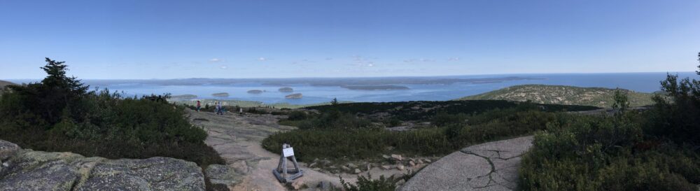
Jeanne’s sister Cindy joined us for a stroll at Hoover Dam and the Mike O’Callaghan – Pat Tillman Memorial Bridge. I half expected Lake Mead to be closer to full than it was, but it wasn’t much different than the last time we were here.
Jeanne and her big sis Cindy strolling across the bridge. Birdseye view of Hoover Dam and Lake Mead.Welcome to the Mike O’Callaghan – Pat Tillman Memorial Bridge.Looking over the top of the dam.The Colorado River, Hoover Dam, and Lake Mead.
Jeanne located Bootleg Canyon Park on the north side of town. We took Woodrow Wilson on a stroll along a trail filled with various statues of desert critters and a little descriptive plaque for each. Not a long walk, but there happens to be a nice paved bicycle path which is a 30-something miles stretch; I’m told you can ride it all the way back into Vegas. Unfortunately we ran out of time before we could give the bike trail a go.
Welcome to Bootleg Canyon Park.We found dat wascawy wabbit!Jeanne & Woodrow Wilson checking out the Gila Monster. A desert Horned Lizard, often misidentified as a Horned Toad.The Roadrunner, without Wile E. Coyote on his tail for once… Hold on! We’re about to jump to blinding speed on this desert tortoise.My, the rattlesnakes here are rather large!A new Olympic Summer Games sport… Desert Scorpion Surfing!
We got our house back, rebuilt engine, all parts working and ready to rock. The only snag, while we were still waiting for the SCR catalyst to be replaced, Jeanne got the phone call, her mom (who lives in Coarsegold, CA) was taken to the hospital due to severe reaction to her current round of chemotherapy. Needless to say, Jeanne was chomping at the bit to get finished at Cummins. Then, it was back to Coarsegold, CA for us. About 8 hours on the road, heavy rain and pea soup fog, not one warning light or siren, and we were settling in to our new temporary home at Park Sierra, the Escapees RV Park in that area. It really is a nice park just outside Yosemite NP, and you can’t beat the weekly rate of $16/night for FHU’s and all the squirrels and rabbits you can stand.
One of our favorite things, driving 36,000 lbs. of steel, plywood, and fiberglass through pea soup fog!Laundry room at Park Sierra. Back deck to the clubhouse, BBQ central it looks like. Park Sierra’s game room. Dart boards in the game room. I’m not all that sure I want to be in the same room with septuagenarians and octogenarians throwing sharp projectiles anywhere! Trail up to the dog run. Can you guess the overall theme of this SKP park?Horseshoes anyone?Pickleball courts. Park Sierra’s clubhouse/office.Front door to the clubhouse.Scenic garden area. I think I caught someone in the outhouse…Our yard at Park Sierra… He caught him some roadkill squirrel! Yummmmmmm!
So for now, that pretty much catches us up. We planned on a return jaunt through Yosemite NP, but the weather gods are angry with us and steady rain is upon us, with our departure from the area due this week. So, no updated photos of El Capitan, Half Dome, etc.
Still no update on our “barely there” battle with Cummins corporate. We did garner the attention of one of the higher-ups, who is currently still looking into our situation. But I hold my breath NOT for a positive outcome on our behalf.
Until next post… As usual, my lack of computer tech skills leads me to apologize if any of the photos are sideways. My displeasure with WordPress as a blog platform continues to grow as it continues to prove to me its user-unfriendliness.